|
I2MOV - Radioamatore |
|
I2MOV QTH - Breme PV |
| INDEX | I2MOV-INFO | I2MOV-RIG | I2MOV-QTH | VIAGGI | QSO & QSL | STORIA | NORME | VARIE | LINKS |
| DESCRIZIONE | |
| FOTO DI BREME - PV | ITALIANO |
| FOTO DI BREME - PV - FIUME PO | ITALIANO |
| DESCRIPTION | |
| TRAVEL INSTRUCTION TO ARRIVE IN BREME | ENGLISH |
|
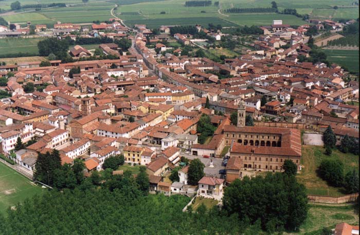
Il mio QTH e' Breme (Pavia) che si trova a circa 70 km Sud/Ovest di Milano; Breme e' un paese di circa 1000 abitanti situato nel sud ovest della Lomellina dove il fiume Sesia entra nel Po. Latitudine : 45 07 37 Nord - Longitudine : 08 37 27 Est. Altitudine: 101 m s.l.m. - La principale attivita' e' la coltivazione del riso e degli ortaggi; molto rinomata e' la cipolla rossa di Breme De.CO. A Breme si trova l'Abbazia di San Pietro costruita nel 906, oltre 1000 anni fa, dai monaci Benedettini della Novalesa. Dopo il 1543 l'Abbazia e' stata occupata dai monaci Benedettini Olivetani fino al 1784 quando fu soppressa e trasferita allo Stato. il WW Locator di Breme e' JN45HD
|
|
My
QTH is Breme (Pavia) about 70 km South/West from Milano;
Breme is located in South West Lomellina, Pavia province, Lombardia region, a few km East from the Po and Sesia rivers. The WW Locator of Breme is JN45HD
|
| INDEX | I2MOV-INFO | I2MOV-RIG | I2MOV-QTH | VIAGGI | QSO & QSL | STORIA | NORME | VARIE | LINKS |
Ultimo aggiornamento: 09-01-16